

How Satellite Technology is Helping to Keep Pipelines Safe
Increased competition and the rising regulations from the government have driven many of the technological improvements in the pipeline industry in recent years. Ageing pipeline systems are incurring higher operating costs to meet the rigid safety standards. Recent decades have shown a significant drop in pipeline accidents, such as oil spills or leakages, but have yet to meet the expectations of the public.
Risk management is the best method for the pipeline industry to address public and environmental safety. Greater efficiencies and better cost control is a priority for any oil and gas company. The present trend in the pipeline industry is to maintain an accurate flow measurement while appropriately streamlining processes for its distribution both internally and externally.
Satellites
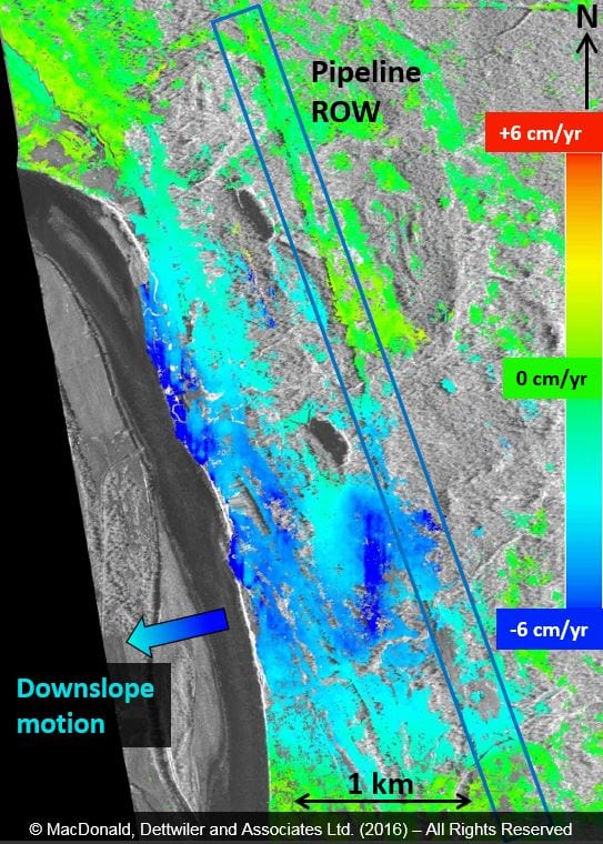
Much of this can actually be monitored from space through satellite technology. This timely pipeline monitoring system will detect the leaks and shifts in the ground near pipelines. Through daily pipeline monitoring, satellites can help these companies detect any new obstructions on land and even underwater.
Satellite monitoring has two basic functions
- To prevent third-party encroachment (thieves stealing oil and gas)
- To develop and deliver a reliable and economical means of monitoring pipeline assets using Earth Observation Data.
A few years ago in Singapore, a group of 17 people managed to steal 6,600 tons of oil from Shell, the sixth biggest oil and gas company in the world. Singapore is southeast Asia’s main refinery hub and the world’s biggest marine refueling stop.
For pipeline operators, safety is paramount. The accidents tend to be serious enough to endanger many lives, destroy the environment, and even cost millions of dollars. Pipelines typically traverse various environments (usually extending for hundreds of kilometers), most of which are not owned by their operators. In some areas, they are isolated with minimal impact on lives, while in other areas they cross dense population networks. The higher the potential impact of a disaster, the stricter and more frequent the required monitoring.
Most pipeline operators are not equipped to conduct this kind of monitoring independently and need an external remote sensing company to address this need. Pipeline operators need more than the regular checks; they need a constant pipeline monitoring system that analyzes the satellite imagery and then alerts them of any unusual activities or changes around their pipes. With GIS-enabled services and high-resolution imagery, this is possible.
Drones
Tagged along with the satellite-based solution, drones are also useful devices when it comes to pipeline monitoring. In order to automate the entire process after identifying the specific areas of interest, drones can be sent to collect this data. Through the process of true automation, drones can replace field operatives in the process of validating. This is especially useful in improving the cost-efficiency and speed of the entire process. Drones provide high-resolution data and can detect extremely small defects in specified infrastructure and areas, and they can be remotely operated and controlled from something as simple as a laptop or tablet.