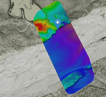
Topographical Surveying and Mapping
Submar can provide topographical surveying services via a site assessment survey that will assist us in engineering design. Our surveying equipment consists of RTK GPS, robotic total stations, and unmanned aerial vehicles (a.k.a. drones) that collect the project site data. After the data is collected, civil designers use AutoCAD 3D software to create measured drawings that will serve as base maps for the proposed design improvements. In addition to the measured drawings, other deliverables include 3D models, aerial videos, and aerial photos.
Engineering Analysis, Design, and Technical Specifications
Submar can provide an engineering analysis and design solution for all types of erosion and pipeline protection problems. Our design solutions can include mechanically stabilized earthen (MSE) walls, articulating concrete block mats (ACBM), lightweight ACBM (wind) mats, longitudinal peaked stone toe protection (LPSTP), riprap/stone materials, bendway weirs, steel sheet pile, and turf reinforcement mats (TRM). We can develop technical specifications covering the many manufactured products that become part of our designs.
Post-Construction Engineering Services
We offer engineering services consisting of project monitoring and performance after our projects are constructed. Immediately after construction is completed and the project is accepted by the client, we will document site conditions that will serve as a baseline for comparison to site conditions in subsequent years. Site conditions can be documented by conducting a topographical survey as discussed above and analyzing the surveys to determine whether site conditions have changed such that they may hinder the performance of the design improvements. We can make recommendations to improve system performance or to prevent a complete failure of the design improvements in the future.
Learn more about our professional services for your project.


